The Salem Summits Project
- Rory King
- Dec 21, 2017
- 6 min read
The high places have always called to me. I don’t know if it’s the perspective gained, the sense of personal accomplishment, or just being that much closer to the heavens - whatever the reason, the pull has always been there, tugging uphill until there’s nothing left to climb and you’re left standing on top of the world. The giant Cascade volcanoes are obvious goals for any climber, but their prominence makes it all too easy to overlook the smaller summits around their feet. These highpoints make great destinations themselves, but are invaluable conditioning opportunities for the mountaineer-in-training. I’ve recently made an effort to visit the high places of the nearby Old Cascades and catalogue them in what I’m calling, The Salem Summits Project.

One evening this spring I drove up the Little North Santiam, threw on a pack, and raced up Henline Mountain. I went out there solely for a workout, but found superb hiking, abundant wildflowers, and the remnants of a decommissioned fire lookout on an exposed point near the top. I stopped to catch my breath and revel in the beauty of this special place up there in the clouds. Then I noticed the others. All around me were similar points, rocky caps and odd protrusions from the rounded foothills, volcanic leftovers of some of the oldest peaks around. What would the others be like? I had to know.
I made a challenge for myself. I’d bring my mountaineering pack, a 10 liter Dromedary for training weight, and the usual day hiking essentials. I'd click my stopwatch at the trailhead and set off on a mission to get to the top as quickly as possible. Running wasn't allowed, but most the time my cardio prevented it anyway. I wouldn't stop until I ran out of trail. On the summit, I'd drop my pack and wander around taking in the views in every direction. Eventually I'd choose a favorite, sit down with some dinner, and watch the shadows stretch out across the valley below me. I'd stay up there for as long as I cared to; the pressure was off and this was the time to sit back and appreciate being up in the mountains. Sometimes I'd race nightfall back to the car, other times I'd stick around on the summit for sunset, knowing fully well I'd be getting back by headlamp.
I genuinely love seeing the mountains this way. There's the aerobic challenge of moving quickly up steep terrain, yet still plenty of time to slow down and take in your surroundings. Hiking these smaller points can simulate the physical challenges of alpine travel, while exposing you to only fraction of the hazards. There’s no technical rope travel to worry about, limited rockfall or avalanche risk, and usually only mild exposure near the top. For this reason, they’re my go-to adventure when I can’t find a partner for the mountains or don’t have safe conditions for a bigger climb.

So, what do you say? Want to hike a Salem summit? Salem’s outdoor club, the Chemeketans, has been organizing training hikes on these trails for years. It's this program that first turned me onto the idea. Check into their website for more details then get out and hike with some new friends! Not only are the group leaders great company, but also great resources for finding other similar trails in the area. Here’s a quick look at some some of the most notable summits out our back door in the Old Cascades.
Opal Creek Area
Henline Mountain
7.1 miles round trip (to true summit)
Elevation gain: 3114’

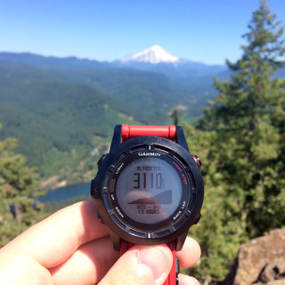
Henline Mountain is one of the first trailheads you pass after leaving the pavement on the North Fork Road. The trail is moderately steep, but well defined and easy to follow (even by headlamp). On the way up there are intermediate views and some really cool rock outcroppings. Henline mountain is unique because the best destination up there isn’t the true summit - it’s a rocky point just a little bit below. The decommissioned lookout site gives great views upriver into the upper reaches of Opal Creek Wilderness Area. Easily one of my favorites.
Nasty Rock
7.0 Miles round trip
Elevation gain: 3852’ (to Nasty Rock)


Nasty Rock offers a couple miles of steep switch-backed National Forest trail that makes a great workout. This trail does leave you a bit short of the destination, however. To reach Nasty Rock, or even the imposter “Not Nasty Rock,” requires following a fainter social trail along the ridge and up to the South corner of Not Nasty Rock. This makes a great goal itself, but those with more time and looking for some more adventure can continue along the ridge to the real Nasty Rock. Be advised that the going gets rough here and trail finding isn’t always obvious. Nasty Rock is a great destination however, giving 360 degree views around the Bull of the Woods Wilderness, as well as a rare glimpse into the upper Mollala Drainage.
Whetstone Mountain
8.6 Miles round trip
Elevation Gain: 3,198’


Park at the gate for Opal Creek and make your way down the gravel fireroad as if towards Jawbone Flats. The trail up Whetstone Mountain is the first that branches off to the left and is recognizable by the self-issue wilderness permit station at the junction. This trail isn’t as frequently traveled and the vegetation presses in a bit more. Still, the grade is relatively moderate and it allows a pretty quick tempo to the top. Great outing for a weekend when you’re looking for some solitude in an otherwise crowded area.
Detroit Area
Rocky Top
7.8 Miles round trip
Elevation gain: 4242’


The trail up to Rocky Top has multiple personalities. The first part climbs at an absurdly steep angle, directly up the ridge. It should be noted that that the trail is primitive, unmaintained, and in some places quite challenging to follow - best done in the daylight. The steep ground here is ideal for developing your pacing and at points even incorporating a rest-step. It’s really that steep. After climbing a couple thousand feet up the ridge, you’ll reach the forest service road and the trail for the Natural Arch. On the road, the grade is gentle as it winds towards the upper trailhead for Rocky Top. It’s a welcome breather and a nice change to bang out a couple miles on easy ground. The final trail up to the summit climbs more steeply, but is well maintained and not difficult to follow. Rocky Top’s summit is one of the best around with sweeping views unique position above the North Santiam River valley.
Sardine Mountain
5 Miles round trip
Elevation Gain: 4,448’


Have you ever looked out the window on a drive through the mountains and thought, “hmm...I wonder what it would be like to hike straight up one the side of one of these?” Apparently someone did. It’s a formidable conditioning hike, built to turn couch potatoes into lean, mean, traverse-crushing machines. Apart from being unrelentingly steep, it’s also one of the most engaging hikes on this list. The first two thousand feet of climbing are through dense temperate rainforest - a steep jungle thrash. The second half follows an exposed rocky spine up and up. Probably the best ridge hiking experience in the area!
Dome Rock
9.5 miles round trip
Elevation gain: 3632’


The hike up to Tumble Dome is much better established than first two in the area. It ascends a National Forest trail that climbs at a steady grade and switchbacks on the steepest portions. Near the top there’s an offshoot of trail that heads up to the dome itself. It’s steep, but the views from the top are some of the very best of the Detroit area.
Stahlman Point
4.1 Miles round trip
Elevation Gain: 1647’


Stahlman point is the perfect place to start. It doesn’t climb nearly as high as some of the others in the area, but its summit is no less steep and dramatic. It’s a great way to taste the character of many of these Salem summit hikes without being quite as demanding. The trail cuts through some old growth forest before the real ascent begins. At the top, there’s a short rocky scramble up to a decommissioned lookout site and some of the best views of the Detroit reservoir. Put it on your list!
Thanks for reading and see you on the trail!
Comments